
7.5-Magnitude Earthquake and Tsunami Alert Shake Chile’s Magallanes Region
By Minener Editorial Team | May 2, 2025
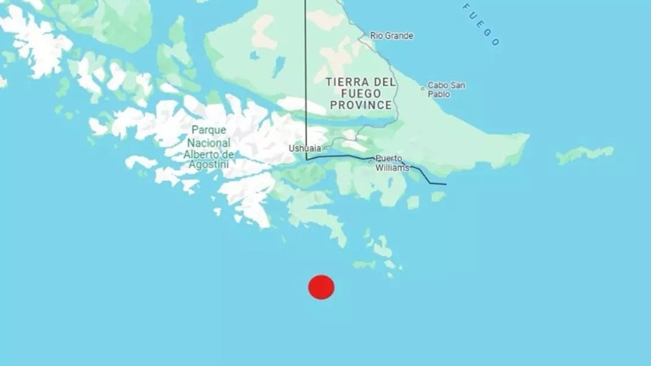
At 08:58 a.m. on Friday, May 2, 2025, a 7.5-magnitude earthquake struck Chile’s southernmost territory, shaking the Magallanes and Chilean Antarctic Region. The epicenter was located in the Drake Passage, 218 km south-southwest of Puerto Williams, at a shallow depth of just 10 kilometers — a factor that intensified the shaking.
The quake triggered widespread alarm, particularly due to the initial tsunami alert issued by SHOA, prompting swift evacuations of coastal and Antarctic communities. It is the most powerful earthquake in the area in over 75 years.
Tectonic Context and Seismic Mechanism
The earthquake occurred in a complex seismic zone where the Antarctic Plate is subducting beneath the Scotia Plate. According to Sergio Barrientos, director of Chile’s Seismological Service, the event was the result of intense compressive stress in a relatively under-monitored sector of the South American tectonic margin.
Unlike the highly active Nazca-South America subduction zone further north — responsible for megathrust quakes like the 2010 Maule event — the Scotia-Antarctica interaction is far less studied. Still, this quake serves as a reminder that Chile’s seismic vulnerability extends well beyond the central and northern zones.
The shallow depth of 10 km allowed for high energy release near the seafloor, producing a slight uplift that, while moderate, was sufficient to trigger tsunami protocols across the southern coastline and Antarctic scientific bases.
Tsunami Alert and Emergency Response
Shortly after the quake, the Chilean Navy Hydrographic and Oceanographic Service (SHOA) issued a tsunami warning. The Senapred agency ordered preventive evacuations across coastal areas of Magallanes and research stations in the Antarctic.
Approximately 2,000 residents were moved inland in towns like Punta Arenas and Puerto Williams, and 32 researchers and personnel were evacuated from remote bases including O’Higgins and Prat.
Minor sea level anomalies were later recorded — 23 cm at the Ukrainian base and 6 cm at the Chilean Prat base — confirming the presence of an “instrumental tsunami”, although no destructive waves developed. The tsunami alert was subsequently lifted for Antarctic territories but remained in place as a precaution in Magallanes.
Damage Assessment and Government Response
President Gabriel Boric, originally from Punta Arenas, suspended his official agenda and coordinated emergency monitoring directly from La Moneda. In a national broadcast, he urged the population to stay calm and follow official channels.
No fatalities or major infrastructure damage have been reported so far. However, the remote nature of the affected zone and ongoing aftershocks — more than 15 recorded — have led emergency crews to maintain heightened alert status.
Impact on Mining Projects in Magallanes
The Magallanes Region hosts several key mining initiatives, particularly in coal extraction, limestone, and exploration of rare earths and hydrocarbons. While not a major copper or lithium hub, the region plays a strategic role in Chile’s diversified mineral base.
Initial reports indicate no major damage to mining infrastructure such as the Invierno Mine on Riesco Island, which is in a suspended state but still monitored. However, experts warn that the quake may have destabilized overburden material or access roads critical for reactivation or exploration logistics.
Chilean mining authorities have launched inspections in coordination with SERNAGEOMIN to ensure slope stability and seismic resilience of underground works or old shafts, particularly near Porvenir and Tierra del Fuego.
Energy Infrastructure: Gas, Oil, and Power Resilience
The earthquake also raised alarms around critical energy infrastructure, including ENAP’s oil and gas terminals in Punta Arenas and the Cabo Negro thermoelectric plant. As of the latest statements, there were no operational disruptions, but preventive shutdowns and pressure valve checks were activated immediately after the quake.
Chile’s southernmost electric grid, which services isolated towns and bases, registered momentary frequency deviations and minor outages in Puerto Williams and nearby naval installations. Backup diesel and hybrid generation systems helped restore power within an hour.
Authorities reaffirmed the importance of decentralized energy systems and storage capacity for emergency resilience, especially under harsh winter conditions where energy demand peaks for heating and logistics.
Public Recommendations
- Remain informed via Senapred and Chile’s Seismological Service.
- Avoid coastal zones until authorities officially lift the precautionary status.
- Prepare emergency kits and identify local evacuation routes in case of aftershocks or future events.
Watch: Video Summary
Visual recap of the earthquake and tsunami alert:
Editorial Opinion: A Wake-Up Call for Chile’s Seismic Blind Spot
The May 2nd earthquake was not just a natural event — it was a warning. While Chile is known for its robust seismic response capabilities in central regions like Santiago or Valparaíso, southern Chile remains vastly under-resourced in terms of monitoring, infrastructure, and emergency planning.
The Magallanes region — remote, cold, and sparsely populated — often falls outside the scope of national investment priorities. But this 7.5-magnitude quake proves that nature doesn’t respect geographic bias. The lack of seismic stations, evacuation signage, and reinforced public buildings in cities like Puerto Natales or Porvenir should be a national concern.
Furthermore, the presence of strategic facilities — such as Chile’s Antarctic scientific bases, maritime routes, and the ENAP oil terminals — makes the region geopolitically and economically important. Yet, its seismic vulnerability is treated as peripheral. That must change.
This event should push the Chilean state to rethink its centralist disaster planning. The southern tip of the continent may be far from La Moneda, but it is no less Chilean — and no less at risk.
Sources: El País, AP News, Infobae, Centro Sismológico Nacional